Filter: Categories of Wisconsin Historical Images
Filter: FORMAT_DIMENSIONS of 11 x 9.5 inches
Filter: Categories of Wisconsin Historical Images
Filter: FORMAT_DIMENSIONS of 11 x 9.5 inches

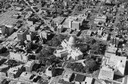
| Date: | 1910 |
|---|---|
| Description: | Bird's-eye view. Caption reads: "Madison, Wis. and the Four Lake Region." |

| Date: | 1956 |
|---|---|
| Description: | Aerial view of the new Madison television facility, WISC-TV (Channel 3), showing the transmitting tower in construction. The location is to the southwest,... |

| Date: | 1948 |
|---|---|
| Description: | Aerial view of the Wisconsin State Capitol and surrounding area looking south southeast towards Lake Monona. |

| Date: | 1955 |
|---|---|
| Description: | An air view of Madison's downtown area with the Wisconsin State Capitol and new State Office Buildings. |

| Date: | 1950 |
|---|---|
| Description: | Aerial view of the Madison isthmus looking north. Caption reads: "Madison Wisconsin — Between Lake Mendota and Lake Monona". |

| Date: | 1956 |
|---|---|
| Description: | Aerial view, looking eastward from a point several miles outside the southwestern limits of Madison in the direction of Verona. Crossing the image diagonal... |

| Date: | 1956 |
|---|---|
| Description: | Aerial view looking east along Madison's Lake Mendota shoreline. The large building under construction at center is Carroll Hall, a University of Wisconsin... |

| Date: | 1919 |
|---|---|
| Description: | Colorized aerial view of isthmus looking northwest over the Wisconsin State Capitol. Caption reads: "Aeroplane View, Madison, Wis., and State Capitol." |

| Date: | 1956 |
|---|---|
| Description: | Aerial view over the eastern end of Lake Mendota, looking northeast. Maple Bluff is in the foreground and Truax Field is in the background. |

| Date: | 1956 |
|---|---|
| Description: | Aerial view looking south from a point over the Maple Bluff country club golf course (foreground). A new housing development in the mid-ground and Maple Bl... |

| Date: | 1915 |
|---|---|
| Description: | The Bauman house at 27 North Baldwin Street. The house was later occupied by the Herman Kroneberg family. |
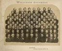
| Date: | 1865 |
|---|---|
| Description: | Composite of portraits of the men of the Wisconsin Assembly. |
If you didn't find the material you searched for, our Library Reference Staff can help.
Call our reference desk at 608-264-6535 or email us at: